Maps locations
There are 3 ways to provide locations functionality on maps site:
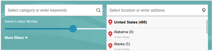
- Use predefined locations - this way users are able to use previously defined locations for their listings. Autocomplete on addresses fields and "Get my location" button on addresses fields should be disabled. So addresses fields will be used by users to manually fill in streets, buildings, postal codes, e.t.c. Also search by address should be disabled in the search form. Visitors will search listings only by previously defined locations drop-down menu. Actually radius search is not necessary in this method.
- Use addresses fields - do not need to insert predefined locations. Users will use only addresses fields, autocomplete function and "Get my location" button on addresses fields can help them. Listings addresses fields (address line 1, address line 2, zip code) should contain whole information about country, state, city, region, streets, buildings, postal codes e.t.c. To get correct search results with nearby locations it is quite recommended to enable search by radius and set up default radius value in the search settings.
- Both methods (default) - usage of predefined locations + addresses fields. But in this case information in addresses fields may contain country, state, city, region, the same as selected predefined locations. It is recommended to exclude locations levels from address line.
Some additional explanation about plugin search engine and its fields here.
Predefined locations
Site admin may create/edit/delete special predefined locations items. Management of directory locations tree has exactly the same functionality as standard WordPress categories, but these are separate items and have special administration page "Maps listings -> Maps locations"
Custom icons may be associated with maps locations displaying in the search form dropdown. Default icons files place in "resources/images/locations_icons/" folder of the plugin. Site administrator can upload custom icons into "w2dc-plugin/resources/images/locations_icons/" folder of your child theme via the Files manager of hosting control panel or via FTP.
The plugin uses only one folder for icons: native folder or custom folder in your child theme when exists.
![]()
After locations levels were successfully configured and locations tree completed - users may select any predefined location from select boxes group on create/edit listing page.
Listings have an option to allow users to select more than 1 location for each listing.
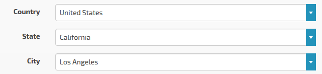
Locations levels
Just in some words, locations levels - these are names of nesting levels of directory locations tree. By default there are 3 locations levels: Country, State and City. Site admin can manage locations levels and exclude any of them from address strings.
When your maps site will be used locally, for example, for visitors from one country or one state/region - do not delete unnecessary locations levels and predefined locations, they are required to set correct location point at the Google map during listings creation/edition. You can just exclude needed locations levels from address line - there is such option for each locations level, it allows to build custom address line at the frontend. See examples:
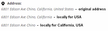
Also when you set up local maps site - it is recommended to fill in "Default country/state for correct geocoding" setting.