Maps & Addresses
This settings tab places on "Directory Admin -> Directory settings" page.
Addresses settings
Default country/state for correct geocoding - this value needed when you build local directory, all your listings place in one local area - country, state or city. This hidden string will be automatically added to the address for correct geocoding when users create/edit listings and when they search by address.
Order of address lines - order address elements as you wish, commas and spaces help to build address line.
Restriction of address fields for one specific country (autocomplete submission and search fields) - restrict autocomplete functionality by maps service only to one selected country or keep it worldwide.
Enable address line 1 field - enabled/disable address line 1 field in locations metaboxes.
Enable address line 2 field - enabled/disable address line 2 field in locations metaboxes.
Enable zip code - enabled/disable zip code field in locations metaboxes.
Enable additional info field - enabled/disable additional info field in locations metaboxes.
Enable manual coordinates fields - enabled/disable manual coordinates fields in locations metaboxes.
Default map zoom level (for submission page) - this zoom level is used during listing submission, the range is 1-19. 1 - the lowest zoom (whole world), 19 - the highest zoom (individual buildings, if available).
Map markers & InfoWindow settings
Allow users to select markers - if disabled - only default markers will be used.
Type of Map Markers - 2 possible types:
- Font Awesome icons (recommended) - icons from the Font Awesome set will be used.
- PNG images - images files from "resources/images/map_icons/icons/" folder of the plugin. Site administrator can upload custom icons into "w2gm-plugin/resources/images/map_icons/icons/" folder of your child theme via the Files manager of hosting control panel or via FTP.
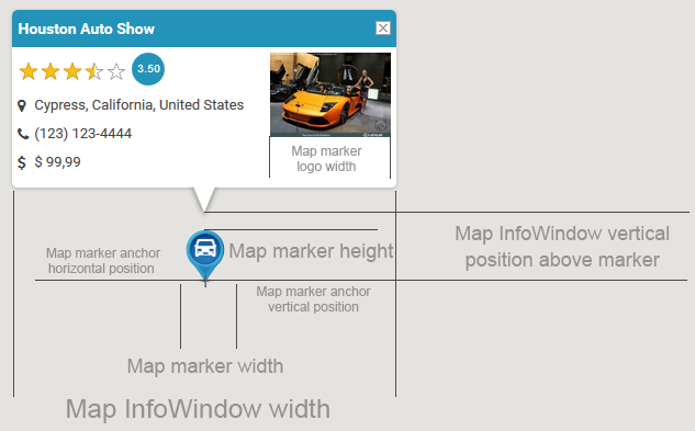
The plugin uses only one folder for PNG icons: native folder or custom folder in your child theme when exists.
Using Font Awesome icons it is possible to select default icon and color of map marker. When "Custom markers on the map" option enabled in listings levels settings - users will be able to select specific icon for each marker. On "Maps listings -> Maps categories" page it is allowed to select specific marker icon and color for each category.
![]()
Other settings related to custom PNG images. Do not touch these settings if you do not know what they mean. Modification of these settings needed when you use own custom map markers icons with own sizes. If you are using custom markers PNG images, it is recommended, they all be of same size.